


|
|
|
|
|
|
| |
| 01.07.2009 | © Erik Aaseth |
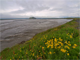
The glacial river Markarfljót is approx. 100 km long, and drains a 1070 km˛ catchment area around the western parts of the Mýrdalsjökull and Eyafjallajökull glaciers.
Then it passes the Ţórsmörk area, and flows full of sulphur, dirt and silt towards the Icelandic SW coast. The lone hill in the middle is called Hákollur.
EDIT 2010: This is where the main flood from the Eyafjallajökull volcano eruption in April 2010 bursted out to sea.
Copyright :© Any picture usage must be permitted in writing by Erik Aaseth.