photo sharing and upload picture albums photo forums search pictures popular photos photography help login
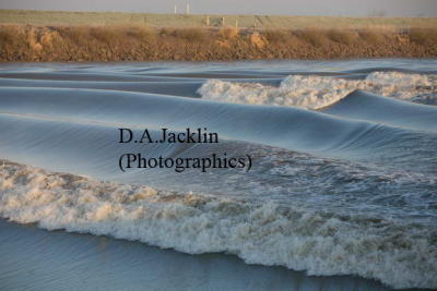
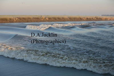
D.A.Jacklin (Photographics) | profile | all galleries >> Galleries >> The River Trent at Susworth .............'Chasing the wave' 2009 tree view | thumbnails | slideshow

The River Trent at Susworth .............'Chasing the wave' 2009

The Trent Aegir and Severn Bore are naturally occurring tidal waves. These natural phenomena occur in the lower reaches of a few rivers throughout the world with large tidal ranges.

The tidel wave is caused by incoming tide rushing up stream from the coast.
There are seven rivers in the world effected by this phenomenon, two of which are in the UK.
The River Trent calls the wave the Aegir and River Severn , the Bore.

The Trent Aegir is named after the god of the seashore or ocean in Norse mythology - and like the Scandinavian sailors in the myths, river people would fear the coming of the aegir as it is very unpredicatable and would sometimes surface to destroy ships. An alternative suggestion for the name Aegir is that it comes from the French Eau Guerre - Water War, from the way the tidal wave travels up the river.
It usually appears during high spring tides, but as with the Severn Bore, its size can be affected by winter floods and the resulting rise in water level. Waves can exceed 2m and its average speed is 16km per hour experiencing the second highest tide anywhere in the world and the difference between the lowest and highest tide in any one day can be more than 14.5 metres. High or spring tides occur on several days in each lunar cycle throughout the year. Although the tides change every day as on the coast, huge variations from hardly a ripple to very large noisy waves depending on many factors........so timings quoted are far from reliable !

The Trent Aegir will be featured in the Scunthorpe evening Telegraph on Monday 6th March,2006

please contact me for further details or for other images or video ............ photographics@jaq.net
(watch this space for TV documentary film (UK) )

* These images were taken on 03/03/06 08.00 hrs in Susworth, North Lincolnshire, UK

Trent Aegir timetable 2010
http://www.environment-agency.gov.uk/static/documents/Leisure/timetable_2-Trent.pdf

These predictions only list those tides that may result in major aegirs. Times are approximate and can vary by as much as 30 minutes either way. It is advisable to arrive early, particularly on weekends or holidays when local traffic congestion can be severe and parking spaces are extremely limited. The link below shows approximate timings,

http://www.environment-agency.gov.uk/static/documents/Leisure/timetable_2-Trent.pdf

The History of the Trent

The Trent is one of the longest rivers in England, meandering 268 kilometres from its source in North Staffordshire to join the Humber Estuary at Trent Falls south of Hull. Its journey takes it through the counties of Staffordshire, Derbyshire, Nottinghamshire, Leicestershire and Lincolnshire.

The Trent is one of only two tidal or bore rivers in England, the other being the River Severn.

The river and surrounding area have been used and populated by humans for thousands of years. From farming to industry, invasions to angling, all have influenced and shaped the area and in some cases had a direct impact on the river itself.

Archaeological remains and villages dating back to Saxon times give us a flavour of the rich and varied history of the River Trent. Nowadays the river is navigable for 151km from Shardlow near Derby to Trent Falls, where it meets the Humber. Evidence suggests that sections of the river may have been navigated as far back as the Bronze Age, while the Danes and Anglo-Saxons sailed up the Trent to invade England.

Legend has it that the place where the Danish King Canute tried to hold back the tide is on the Trent at Gainsborough Riverside.

The Romans referred to the Trent as Trisantona, the river marked the limit of the first phase of their advance: reaching it within four years of landing in force in 43AD, they halted and did what we would now call 'digging-in'. All their settlements were to the south, with a line of fortresses along the river itself, served by their great new roads; the Fosse Way and Ermine Street. The Trent remained the outermost frontier of the Roman Empire until 79AD.

The river and its tributaries flow through some of the most industrialised parts of the Midlands, and during the 18th and 19th centuries the Trent played a major role in the industrial development of the area. With populations now reaching over one million in the cities along the Trent, together with the influences of industrial and agricultural development, including mineral extraction, drainage and built development, the river’s wildlife did decline during the last century but wildlife has had a chance to recover. Increases in fish numbers, including species such as salmon, together with sympathetic management have spelled good news for creatures such as the otter, which is experiencing a welcome and widespread return along the river. Much of the recovery can be attributed to local landowners.

Portrait of the River Trent

From a source at Biddulph Moor, the River Trent flows 171 miles until it enters the North Sea beyond Hull. It is the third longest river in England, after the Thames and the Severn. The river has more than 20 tributaries. The name 'Trent' is derived from the Celtic trisantona, which means 'road-crosser, flooding river, trespasser, wanderer.' I focus here on seven features of the river.

Division The River Trent is the traditional dividing line between the north and south of England: Meteorologically, the weather 'above' and 'below' the river is often different. Ornithologically, some breeds of bird occur only to the north (e.g. curlew, merlin and grouse) or to the south (e.g. nightingale and reed warbler) of the Trent.

Topographically, England's major hills are to its north and lowlands are to its south. Geologically, the main coal reserves are to the north of the river, while the gypsum is to the south. Industrially, the heart of the Industrial Revolution was to the north of the river, whereas the south retained a more agricultural flavour. Linguistically, there are variations of words and pronunciations 'above' and 'below' the Trent. Militarily, the Royalist forces in the Civil War came predominantly from the north; the Parliamentarians from south of the river. Politically, the traditional Labour Party heartlands lie north of the Trent, and of the Conservative Party to the south. Ecclesiastically, the Methodists and Pentecostals prospered to the north, the Brethren and Baptists to the south. North of the river is the Archdiocese of York, south the Archdiocese of Canterbury.


Battle Several important battles have taken place on the banks of the River Trent: On 18 March 1321, Edward 2nd fought the Earl of Lancaster at Burton Bridge. On 16 June 1487, the battle that ended the Wars of the Roses took place at East Stoke (near Southwell). The House of Lancaster defeated the House of York. 7,000 men died and it was said that the river ran red with blood. On several occasions during the Civil War in the 1640's, the Royalists and Parliamentarians clashed at Trent Bridge, Nottingham. In 1745, Bonnie Prince Charlie and his Highland Army reached as far south as Swarkestone Bridge, Derby, before retreating north to defeat at Culloden.
Invasion A river represents a highway along its course as much as it does a barrier to those trying to traverse it. Since the Trent has been navigable for much of its history, this inevitably led to its use for invasion: The Romans reached as far north as the Trent in 47 AD. Having consolidated their position, they crossed the river and moved further north in 79 AD.

Celts such as Wulfhere, the 7th Century King of Mercia, navigated the river to Stone, from where he ruled his kingdom. The River Trent was the major route into England for the Vikings. Place-names such as Normacot and Knutton show that they made it right to the source of the river.

The Danes established the Danelaw in the five boroughs of Nottingham, Derby, Leicester, Lincoln and Stamford. Sweyn Forkbeard, King of the Danes, died in Gainsborough in 1040.


Trade In peaceful times, the river was used for the purpose of trade: As early as the 14th Century, goods were being moved between Nottingham and York. By the 17th Century, this amounted to 10,000 tons annually. In the 18th Century, this rose to 75,000 tons annually.

With the opening of the Grand Trunk (i.e. Trent and Mersey) Canal in 1766, the world opened up to the pottery industry. Goods could be transported westwards to Liverpool (and the USA) and eastwards to Hull (and Europe).


Worship The River Trent has had a long association with Christian worship. This was particularly focused on the 'holy places' that lay at the confluence of two rivers/streams:

At Southwell in 630 AD, Paulinus, the 1st Archbishop of York, baptised the local population in the River Trent. Southwell's original name meant 'the place where much industry was employed in the laying on of hands.' A monastery
A monastery was established at Repton (Burton) in 650 AD. Around 700 AD, holy places were built by St Chad at Stoke-upon-Trent and by St Werburgh at Trentham. St Modwen, the Irish princess and missionary, founded a monastery on an island at Burton-on-Trent in 900 AD. Established in 1000 AD, the Benedictine Burton Abbey was the largest abbey in Staffordshire. A Cistercian Abbey was erected at Hulton (Stoke-on-Trent) in 1170 AD.


Revival Alongside the ancient places of worship and witness, there are more recent links between the Trent and non-Conformist revivals. Revival leaders born along the river include:

John Wesley (leader of Methodism, born at Epworth in 1703)
Hugh Bourne (co-leader of Primitive Methodism, born at Bucknall in 1772)
William Clowes (co-leader of Primitive Methodism, born at Burslem in 1780)
William Booth (founder of the Salvation Army, born at Nottingham in 1829)
At least two 19th Century revivals flowed along the River Trent:

Primitive Methodism was born at Mow Cop, within a mile of the source of the river. In the person of William Clowes, it moved through Staffordshire, Derbyshire, Nottingham, Leicestershire and Yorkshire, until it reached the mouth of the river at Hull. As a result of Clowes' labours in Hull and the north, 12,000 members were won in seven years.

Gypsy Smith, a young Salvation Army officer, experienced a great revival in Hull between January and June 1881. He then spent the second six months of 1881 on mission in Derby. He served in Hanley from 1 January 1882, gathering 10,000 people from a standing start in just six months.


Power The River Trent is associated with power. Electricity-producing power stations run along its banks in Meaford (Stone), Rugeley, along the A50 and near Nottingham. 20% of the nation's electricity is generated by power stations along the river, with 75% of those stations situated on its northern banks.

Further information and details of Aerial and ground 'Film documentary ' to be produced 2008/9 please contact me at ; photographic@jaq.net
previous pagepages 1 2 ALL next page
Aegir 1946 .JPG
Aegir 1946 .JPG
AegirSusworth_01.jpg
AegirSusworth_02.jpg
AegirSusworth_03.jpg
AegirSusworth_04.jpg
AegirSusworth_05.jpg
AegirSusworth_06.jpg
AegirSusworth_07.jpg
AegirSusworth_08.jpg
AegirSusworth_09.jpg
AegirSusworth_10.jpg
AegirSusworth_11.jpg
previous pagepages 1 2 ALL next page