Nanga Parbat, Gilgit-Baltistan (Formerly Northern Areas), Pakistan - 2005 Trip
|
Taxila - Indus Valley Civlization - Khyber Pakhtunkhwa (Formerly NWFP), Pakistan
|
Government College University, Lahore (GCU, formerly GC) - Punjab, Pakistan
|
Garhi Habibullah Khan and Muzaffarabad - Khyber Pakhtunkhwa (Formerly NWFP) & AJK, Pakistan
|
Kaghan Valley, Lake Saiful Mulook and Malika Parbat - Khyber Pakhtunkhwa (Formerly NWFP), Pakistan
|
Good old Lahore - Punjab, Pakistan
|
Gilgit-Baltistan (Formerly Northern Areas), Pakistan - Deosai, Skardu, Rakaposhi
|
Quetta to Lahore Jan '06 - Balochistan, Pakistan
|
Malam Jabba 2005 - Swat Valley, Khyber Pakhtunkhwa (Formerly NWFP), Pakistan
|
Manora Island Beach - Karachi, Pakistan
|
Mangla Dam Trip - March 2002 - AJK, Pakistan
|
Faisal Mosque, Islamabad, Pakistan
|
Maps of Pakistan
Maps of Pakistan
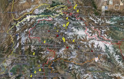
Northern Areas of Pakistan - Overview Map.jpg |
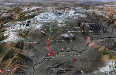
Nanga Parbat Tilted Map- Marked Trails.JPG |
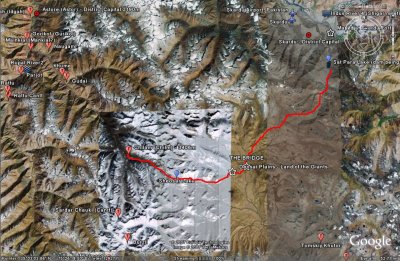
Deosai Plains Map - Marked Trail.jpg |
click on thumbnails for full image


